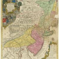
Pensylvania Nova Jersey et Nova York cum Regionibus ad Fluvium Delaware in America sitis ...
Dublin Core
Title
Pensylvania Nova Jersey et Nova York cum Regionibus ad Fluvium Delaware in America sitis ...
Subject
Pennsylvania, New Jersey, New York, Delaware, and parts of New England
Description
Map of Pennsylvania, New Jersey, New York, Delaware, and parts of New England. Cartographic elements include locations of rivers and settlements, some topographical details, scales, compass rose, degrees of latitude and longitude. Decorative cartouches includes native Americans or blacks smoking a pipe, leaning against a musket or gun, offering a basket of fish to a European gentleman, rabbits, deer or stag, turkey, bear [?], snake, birds, and bales of tobacco, a woman holding a sheaf of wheat who sits beside the royal English coat of arms.
Creator
Tobias Conrad Lotter
Source
John Carter Brown Library
Date
1758-1777
Format
engraving, hand coloring
56.7 x 49 cm.
56.7 x 49 cm.
Language
German
Type
map
Coverage
Colonial America
Files
Collection
Citation
Tobias Conrad Lotter, “Pensylvania Nova Jersey et Nova York cum Regionibus ad Fluvium Delaware in America sitis ...,” Stories of the Susquehanna Valley, accessed May 12, 2024, http://ssv.omeka.bucknell.edu/omeka/items/show/1088.
