Shamokin's Monuments: An Interactive Map
Tyler Candelora, Bucknell University '19
The rich history and heritage of firefighters, policmen, and veteran soldiers from the Shamokin area is reflected in the disportionately large number of monuments and memorials built around the town. This project examines: “what cultural significance do Shamokin and Coal Township’s monuments have in relation to the events they commemorate?”
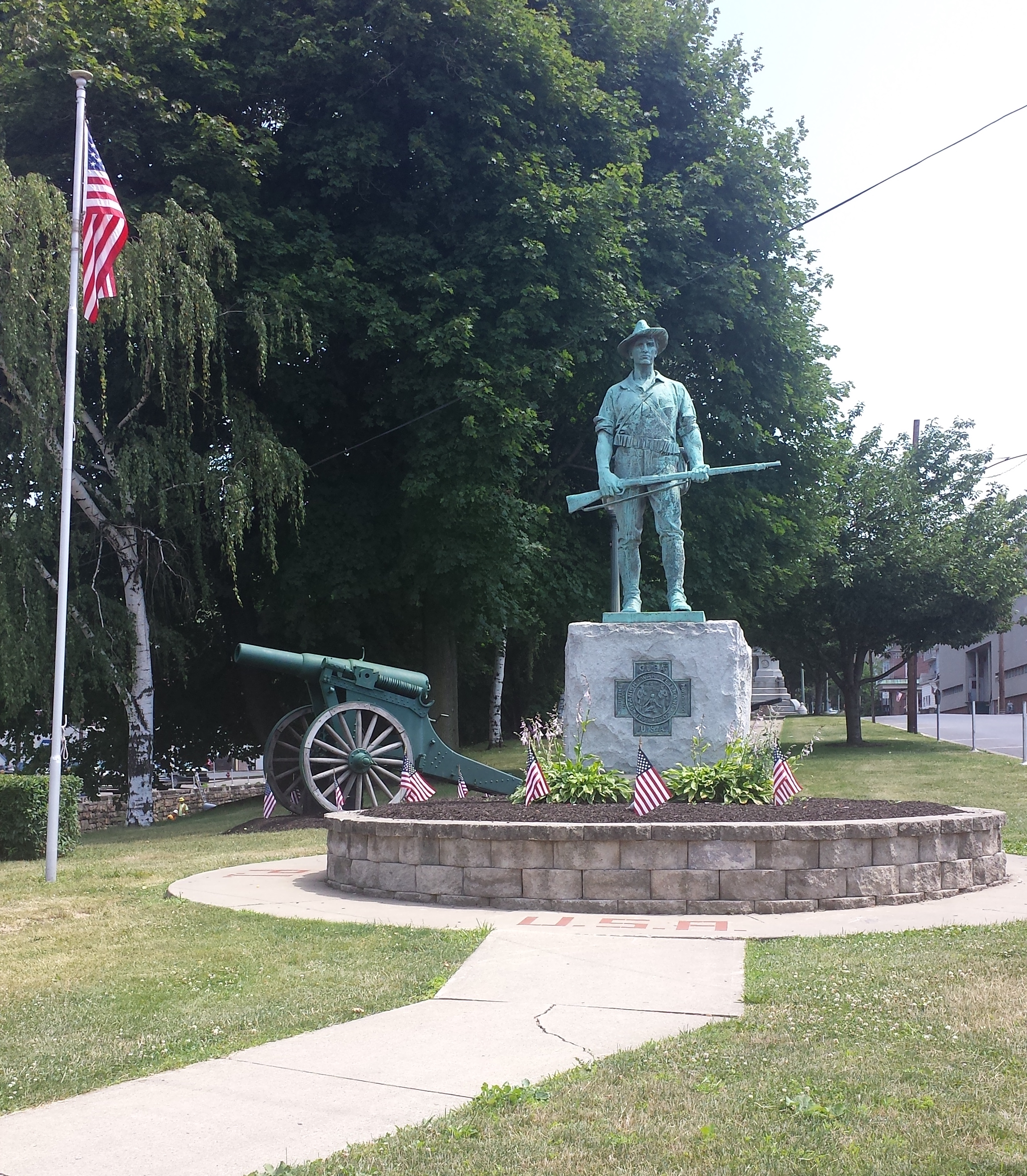 At first glance, the memorials and monuments may be difficult to spot until you drive down Lincoln Street to the corner of Market Street. In one block, you can see nine decades of Shamokin’s history when you walk past the Soldiers and Sailors Monument (1898) down to the Hiker Monument (1938). It is clearly evident that the citizens of Shamokin recognised heroism and courage in those who were willing to sacrifice their lives for freedom. Five of the ten monuments I have documented are based on veterans from Shamokin and Coal Township.
The other five monuments in the town all have specific reasons for their existence; however, heroism and courage are still a crucial aspect. There is a memorial to a fallen firefighter, Timothy DiOrio, and a fallen police officer, Cpl. David Witmer. Also, there is a monument dedicated to the volunteer firefighters from the five Shamokin fire houses.
The monuments and memorials in the Shamokin area reflect the unequivocal virtues of contribution and service. For this reason, Shamokin “contributes” to those people by creating a lasting impression on the city – a monument/memorial. It is a time capsule that commemorates those who have left an impact on society. These monuments allow for the transfer of cultural knowledge, providing a space for reflection and admiration. As of August 2016, another monument is being built on Lincoln Street – there will be five on that street alone. This new monument will include the Golden Eagle emblem which was saved after the razing of the Shamokin Realty Building. There will also be engraved pavers dedicated to those workers of the Eagle Silk Mill from Shamokin and Coal Township. In addition to the new monument, Lincoln Street has become a popular location for Pokémon-Go trainers. This new video game via mobile cellphones has many people adventuring around the city, which is a great way to explore Shamokin’s monuments.
If you follow this link: http://ssv.omeka.bucknell.edu/omeka/neatline/show/map-of-shamokin-and-coal-township, it will take you to an interactive map of Shamokin and Coal Township’s monuments.
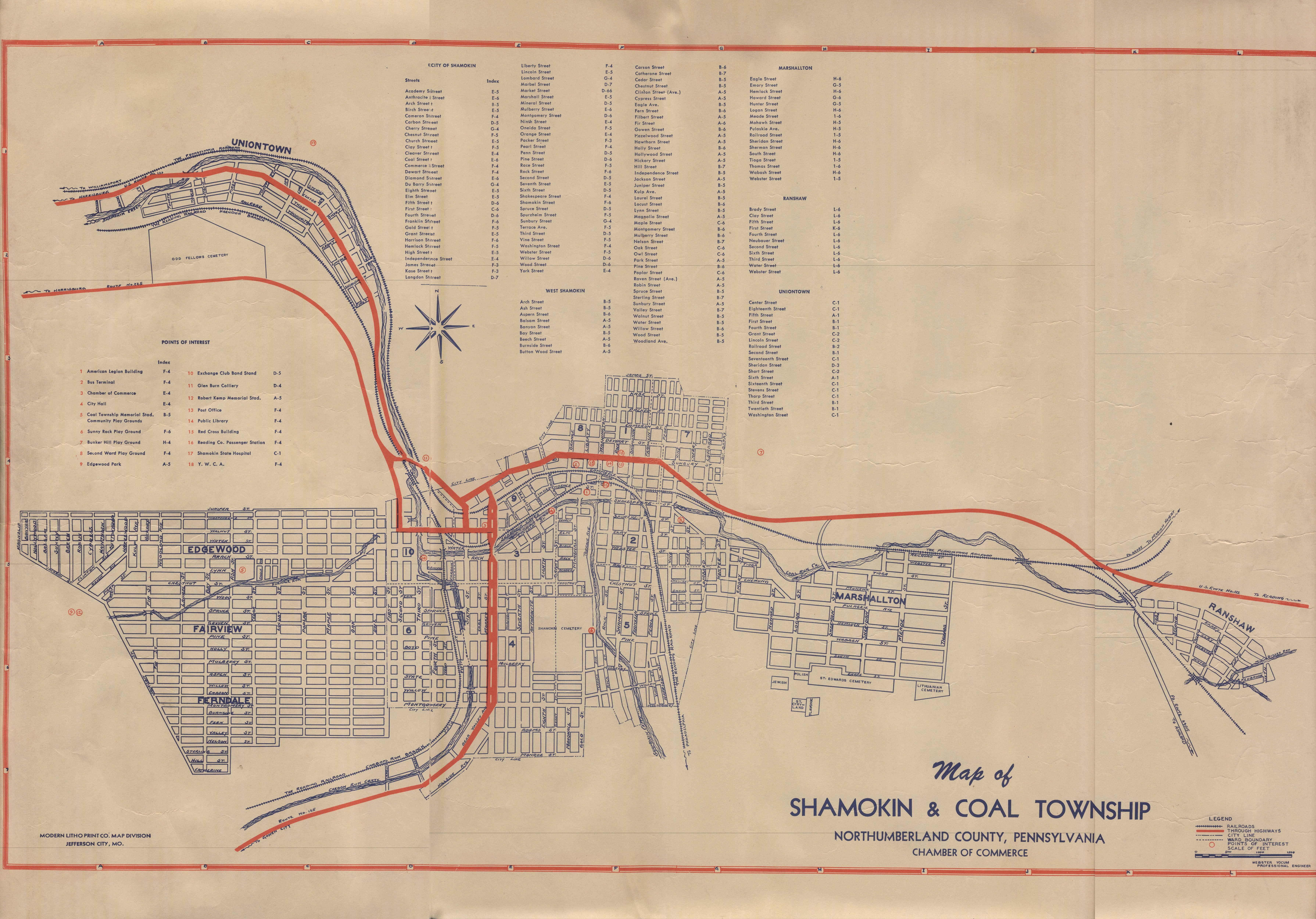 The monuments are light blue and the fire houses and old Shamokin police station are in purple. The fire station and old Shamokin police station are included on the map to help with the spatial understanding of the monuments. Thus, it is clear that the DiOrio monument is closer to the Maine Fire Co. because he was a member of that station, and the Cpl. David Witmer memorial is closer to the old Shamokin police station because he was an officer of that station, etc.
In order to allow the reader to have a firsthand look at the history of the monuments, I have added the newspaper articles about the occasion of the monument being erected for every monument but one. Unfortunately, I could not find the 1898 article of the soldiers and sailors monument. If anyone can locate this article, I would very much appreciate it - contact me (see below). I encourage the reader to click the links (these are the newspaper titles - e.g. Shamokin Citizen, Shamokin News-Item, etc.) to zoom in and out of the articles and photos of the monuments making them easier to read. Most of the articles are from microfilm, which produces a lower quality, but the digital images are made at a very high resolution. There are a few monuments that have more than one article; I chose some miscellaneous articles that I thought were interesting and cohesive within the bounds of my project. These types of articles could be an obituary, the cause for the monument to be built, or an interesting fact about the monument.
The base map is Modern Litho Print Co (Map Division) of Jefferson City, MO dated between 1950 to 1960. I cannot pinpoint the exact date; however, I picked a map in this time range because it is directly between the boom of monuments/memorials being built in Shamokin. Also, it adds to the historical trend of my research.
Acknowledgements:
This project was sponsored by the Emerging Scholars Program with funding from the Bucknell Institute for Public Policy, the Bucknell Center for Sustainability and the Environment, and the Office of the Provost.
Professor Katherine Faull, Ph.D, Comparative Humanities, research mentor
Dr. Diane Jakacki, Digital Scholarship Coordinator
Northumberland County Historical Society
Shamokin Public Library
Bibliography:
Warner, Marina. Monuments & Maidens: The Allegory of the Female Form. New York: Atheneum, 1985. Print.
Riley, Alexander. Angel Patriots: The Crash of United Flight 93 and the Myth of America. New York: NYU, 2015. Print.
Webography:
The Effects of Public Memorials on Social Memory and Urban Identity
By Ebru Erbas Gurler, Basak Ozer
http://www.academia.edu/10759154/The_Effects_of_Public_Memorials_on_Social_Memory_and_Urban_Identity
Contact info:
Tyler Candelora, tdc008@bucknell.edu