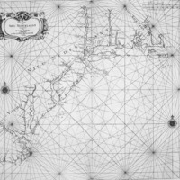
PASCAARTE VAN NIEU NEDERLANDT
Dublin Core
Title
PASCAARTE VAN NIEU NEDERLANDT
Description
In the year 1656 Arnold Colom published Zee-Atlas, ofte Water-Wereldt, which contains this chart (Burden #316) of the region from Cape Cod to Carolina. Delaware Bay is reasonably shown with the capes named and also the 'Schuyl Kil', kil means river or stream in Dutch. Nothing inland is identified. (from Pennsylvania Regional Maps 1650's)
Creator
Arnold Colom
Date
1656
Identifier
Aa0120z003
Files
Collection
Citation
Arnold Colom, “PASCAARTE VAN NIEU NEDERLANDT,” Stories of the Susquehanna Valley, accessed April 26, 2024, http://ssv.omeka.bucknell.edu/omeka/items/show/61.
