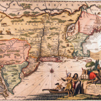
Novi Belgii, quod nunc Novi Jorck vocatur, Novaeque Anglia et partis Virginiae. (New Netherland, Which is Now Called New York, and New England and Part of Virginia.)
Dublin Core
Title
Novi Belgii, quod nunc Novi Jorck vocatur, Novaeque Anglia et partis Virginiae. (New Netherland, Which is Now Called New York, and New England and Part of Virginia.)
Description
Beautiful full color example of the Ogilby's map of the the Northeast, extending from the St. Laurence and New England to the Chespeake and centered on Long Island, which is still shown as an island.
The first state of the map, which was later re-issued by Vander Aa. Includes an ornate scene of Europeans and Native Americans trading. The map includes extraordinary detail along the Atlantic Coast, Hudson River, Delware River and Bay and the Chespeake. Includes a compass rose and a number of animals in the body of the map, retained from the earliest editions by Jansson & Visscher. The Jansson-Visscher map, in it various forms, was the most influential map of the region for nearly 40 years. (from Barry Lawrence Ruderman Antique Maps Inc.)
The first state of the map, which was later re-issued by Vander Aa. Includes an ornate scene of Europeans and Native Americans trading. The map includes extraordinary detail along the Atlantic Coast, Hudson River, Delware River and Bay and the Chespeake. Includes a compass rose and a number of animals in the body of the map, retained from the earliest editions by Jansson & Visscher. The Jansson-Visscher map, in it various forms, was the most influential map of the region for nearly 40 years. (from Barry Lawrence Ruderman Antique Maps Inc.)
Creator
John Ogilby
Date
1671
Format
14.5 x 11 inches
Identifier
Aa0118z004
Files
Collection
Citation
John Ogilby, “Novi Belgii, quod nunc Novi Jorck vocatur, Novaeque Anglia et partis Virginiae. (New Netherland, Which is Now Called New York, and New England and Part of Virginia.) ,” Stories of the Susquehanna Valley, accessed April 25, 2024, http://ssv.omeka.bucknell.edu/omeka/items/show/57.
