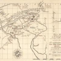
Moravian Mission Map
Dublin Core
Title
Moravian Mission Map
Subject
Map of Pennsylvania and neighboring provinces
Description
Translation of Key on Matthias Hehl's Itinerant Preaching Map
Travel Map through Pennsylvania and other neighboring provinces with annotations of:
All farm properties (green)
places of abode, churches, and schoolhouses (red)
of the United Brethren names Unitas Fratrum
and some of the single families who are connected with them (blue)
as also several inns and waymarkers (yellow)
Also note SCALE MARKER on bottom right hand corner
Creator
Matthias Hehl
Source
Moravian Archives, Bethlehem, PA
Date
1740-1750
Format
Map
Language
German and English
Type
Map
Identifier
Da01z002
Files
Collection
Citation
Matthias Hehl, “Moravian Mission Map,” Stories of the Susquehanna Valley, accessed April 25, 2024, http://ssv.omeka.bucknell.edu/omeka/items/show/549.
