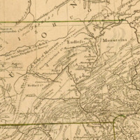
A Map of the Middle British Colonies In North America
Dublin Core
Title
A Map of the Middle British Colonies In North America
Description
A nice example of the second edition of Evans' map, corrected and extended by Pownall.
Along with Mitchell's map issued in the same year, the Evans is considered the most important American map of the 18th Century. Both maps were intended to spur western expansion into the Trans-Allegheny, Ohio Valley and regions westward and in response to French Encroachments. Evans map became the standard for nearly 50 years, being re-issued in this and a number of pirated editions by Jefferys, Sayer Kitchen, Bowles and others.
The map is a milestone both for its political significance and extension of cartographic knowledge in the region. Unlike the pirated editions, Pownall's map is issued from the original Evans plate, with and addition of New England and a group of tables, naming townships in the Colonies. It bears Evans Tribute of Gratitude… in the upper left corner. Pownall had been a great supporter of Evans and pledged the proceeds from the map to Evans' daughter.
(from Barry Lawrence Ruderman Antique Maps Inc.)
Creator
Lewis Evans (original)/ Thomas Pownall
Date
March 25th 1776 (original 1755)
Relation
Streeter, Lewis Evans His Map, pp.17-28; Schwartz & Ehrenberg, p.162, pl. 98; Klinefelter, The Maps of Lewis Evans, 1971.
Format
32 x 19.5 inches
Identifier
Aa0105z003
Files
Collection
Citation
Lewis Evans (original)/ Thomas Pownall, “ A Map of the Middle British Colonies In North America,” Stories of the Susquehanna Valley, accessed April 23, 2024, http://ssv.omeka.bucknell.edu/omeka/items/show/29.
