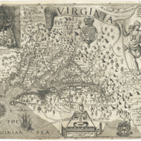
1612 John Smith Map
Dublin Core
Title
1612 John Smith Map
Subject
map of Virginia
Description
Captain John Smith created the first detailed map of the Chesapeake Region. His masterpiece map of Virginia, published in 1612, remained in active use for seven decades and opened this part of North America to European exploration, settlement, and trade. The geographical accuracy is astounding given that Smith traveled about 2500 miles in a series of short expeditions and had only primitive mapmaking tools to work with (from Captain of John Smith Chesaspeake http://www.smithtrail.net/captain-john-smith/smiths-maps/)
Date
1612
Identifier
Aa0101z001
Files
Collection
Citation
“1612 John Smith Map,” Stories of the Susquehanna Valley, accessed April 19, 2024, http://ssv.omeka.bucknell.edu/omeka/items/show/20.
